
Latest News
- June 2025: New Data Migration Service
- January 2025: WinLoG Field Assistant Released
- December 2024: Version 6 of GaeaSynergy Released
- February 203: Version 5 of WinLoG RT Released
- October 2023. Version 5 of GaeaSynergy Released
- June 2023: New Version of E-ASR Released
- March 2023: Switch to WinLoG and Save 50%
- November 2022: New E-ASR Software Released
- October 2022: EDMS and GDMS on Sale
- September 2021: POLLUTE version 8 Released
- March 2020 Work from home using WinLoG RT
- January 2020 New Free Webinars
- July 2019: Geotechnical Data Management System Released
- June 2019: SE-Map is Now Free
- May 2019: StrataExplorer renamed to GaeaSynergy
- February 2017: Buildings and Structures Module Now Free
- October 2016: Get a Free copy of EDMS Field
- August 2016: WinLoG RT Released
- June 2016: Environmental Data Management System Released
June 2025:
Would you like to use the latest version 6 of WinLoG but have a lot of data
in other versions or other software already?
GAEA Technologies can migrate your data whether it is in other versions of
our software or some of our competitors. Depending upon the amount of data
this can be done for as little as $1 USD per project. The data migration is
done in a simple 3 step process as shown below.
To get a quote on your data migration, please contact us at sales@gaeatech.com.
WinLoG Field Assistant Released
January 2025: We are proud to announce the release of WinLoG Field Assistant, our newest version of WinLoG for Android tablets. The user interface has been specifically design to make data collection easier on tablets. WinLoG Field Assistant can be used to quickly and easily collect and print boring and well data for a variety of industries.
Until the end of 2025, receive a free template (log form) customized from one of the supplied templates to meet your needs with the purchase of a perpetual license or annual subscription of WinLoG Field Assistant.
Boring, borehole and well logs can contain optional headers and footers and a large variety of depth related column data. Templates are used to control the layout and formatting of the log. A wide variety of templates are available for download to use in the program. To download your own custom templates, you will need to have the network version of GaeaSynergy or have them created by GAEA Technologies.
WinLoG Field Assistant can be used independently or as a field extension of the WinLoG/GaeaSynergy application. All of the data is stored on the tablet and the logs can be printed directly from the tablet. WinLoG Field Assistant can be used completely independently of WinLoG and does not require any other software.When used in conjunction with the network version of WinLoG/GaeaSynergy, WinLoG Field Assistant can act as a remote data collection device for boring and well data. The data collected in the field can be sent to the network as an Electronic Data Interchange (EDI) file. The GaeaSynergy Network Data Manager service will automatically download the data from the FTP site and merge the data with the main database on the server.
Version 6 of GaeaSynergy Released
December 2024: Version 6 of GaeaSynergy has been released. Some of the new features in this version are:
- Supports data exchange with WinLoG Field Assistant. The newest version of WinLoG for Android devices to be released in January 2025.
- Project categories shown in the project tree can be used to store groups of projects in different folders, drives, or networks.
- Database functionality has been improved to provide more flexibility and robustness, especially when using them across a network.
- Has the ability to upgrade from GaeaSynergy 5 or to import projects, templates, and lithology libraries from GaeaSynergy version 5.
Version 5 of WinLoG RT Released
February 2024: Version 5 of WinLoG RT has been released. Some of the new features in this version are:
- Licenses can be perpetual or subscription based.
- Subscriptions can be annual or monthly.
- Subscriptions can be manually or automatically renewed.
- Licenses can be purchased and registered in WinLoG RT.
- After purchase, licenses can be immediately added and used in WinLoG RT.
- Annual maintenance can be purchased and renewed as a subscription.
- Industries no longer apply to the WinLoG RT. It now has the features of all the industries.
- Instead of specifying depths they can also be picked on the borehole/well logs for lithology, text, text interval, USCS, and formation tops columns.
- A USCS calculator can be used to determine the USCS classification in USCS and lithology columns in borehole/well logs.
- Munsell colors can be specified for lithologies and samples.
- Continuous well logs can be exported to a PDF file as a continuous page.
- Divider lines in lithologic columns of borehole/well logs can be extended to better show contact depths when descriptions are pushed down.
Version 5 of GaeaSynergy Released
October 2023: Version 5 of GaeaSynergy (including the WinLoG, WinFence, EDMS and GDMS modules) has been released. Some of the new features in this version are:
- Licenses can be perpetual or subscription based.
- Subscriptions can be annual or monthly.
- Subscriptions can be manually or automatically renewed.
- Licenses can be purchased and registered in GaeaSynergy or the GaeaSynergy Network Monitor.
- After purchase, licenses can be immediately added and used in GaeaSynergy.
- Annual maintenance can be purchased and renewed as a subscription.
- Industries no longer apply to the WinLoG and WinFence modules. These modules now have the features of all the industries.
- Projects can be archived and retrieved from archives. This allows for the easier selection of current projects.
- Cross-sections can be created manually instead of using the project map by specifying the distances between the boreholes/wells.
- Instead of specifying depths they can also be picked on the borehole/well logs for lithology, text, text interval, USCS, and formation tops columns.
- A USCS calculator can be used to determine the USCS classification in USCS and lithology columns in borehole/well logs.
- Borehole data can be exported and imported to and from DIGGS (Data Interchange for Geotechnical and Geoenvironmental Specialists) files.
- New and improved exporting and importing of borehole data to gINT.
- New and improved exporting and importing of borehole data to AGS.
- Munsell colors can be specified for lithologies and samples.
- In georeferenced projects a topographic map can automatically be created using elevations from Google.
- When creating a new borehole/well in a georeferenced project the elevation is automatically entered using Google elevations.
- Continuous well logs can be exported to a PDF file as a continuous page.
- Divider lines in lithologic columns of borehole/well logs can be extended to better show contact depths when descriptions are pushed down.
June 2023: Version 2.10 of E-ASR (Environmental Autmated Standardized Reporting) has been released. This version includes 4 new questionnaires and report templates. Below is a summary of the new features:
- Added questionnaire and report template for CSA Z768-01 (reaffirmed 2022) Phase I Environmental Site Assessment.
- Added questionnaire and report template for CSA Z769-00 (reaffirmed 2018) Phase II Environmental Site Assessment.
- Added questionnaire and report template for Ontario Regulation 153/04, Schedule D Record of Site Condition for Phase I Environmental Site Assessment.
- Added questionnaire and report template for Ontario Regulation 153/04, Schedule E Record of Site Condition for Phase II Environmental Site Assessment.
- Added ability to add rectangles, polygons, polylines, circles and points with labels as annotation to projects, project templates, and project views.
- Added ability to highlight table execeedences.
- Added ability to save project maps to images for use in reports.
- Added ability to import images into projects.
- Added ability to add image to project view and templates.
- Added ability to capture street views in Google or Bing as images for use in reports.
- Added ability to import and store PDF documents for use in reports.
Switch to WinLoG and Save 50%
March 2023: There has never been a better time to switch to
WinLoG. Until the end of 2023 we are offering a 50% discount for competitive
upgrades. Switch from gINT, LogPlot, Quicklog or any other competing product
and get WinLoG at half off.
Use coupon code COMPUP when checking out
to get your 50% off of a WinLoG single user, additional user or network
licenses.
WinLoG can import gINT version 8 data as well as AGS
version 3 and 4 data. In addition, your WinLoG license will be a perpetual
license, you do not need to pay an annual subscription fee. The license
comes with the first year of annual maintenance. After the first year the
annual maintenance can be optionally renewed for 20% of the list price.
Click here for more information or to order WinLoG.
New E-ASR Software Released
November 2022: GAEA is proud to announce the release of our E-ASR (Environmental Automated Standardized Reporting) software. This software has been more than 3 years in development and is a significant upgrade for our Pocket ESA software.
E-ASR has been designed to minimize the amount of time required to generate standard Environmental Site Assessment reports and to maximize the flexibility of the final report. The program is used to collect answers to pre-designed questions. The data can be collected on a Tablet, Laptop, or Desktop. These answers are then merged with a report template and a standard report is generated. The merging process allows the user to insert different responses and paragraphs into the report depending upon how a question is answered.
A wide variety of reports can be created; including Phase I ESAs, Phase
II ESAs, Environmental Compliance, and Transaction Screening. The reports
can be tailored to any standard such as CSA and ASTM.
The program comes with several questionnaires and report templates (click
on the links below to see example reports generated by E-ASR):
-
ASTM E1527-21 Phase I Environmental Site Assessment
-
ASTM E1903-19 Phase II Environmental Site Assessment
E-ASR is currently being offered at an introductory sale price of 50% off. See below for more information and sale prices.
Click below for more information or to download a free demo.
EDMS and GDMS on Sale
October 2022: EDMS (Environmental Data Management System) and GDMS (Geotechnical Data Management System) are currently on sale for an amazing 70% off. Act fast this sale ends on December 31, 2022.
For prices and more information click on the links below.
EDMS (Environmental Data Management System)
GDMS (Geotechnical Data Management System)
POLLUTE version 8 Released
September
2021: GAEA Technologies is very happy to announce the release of
POLLUTE version 8.This is a significant upgrade to version 7 of POLLUTE and
has a new much more intuitive user interface and many other new features as
described below.
- New models can be easily created using either a blank model or template.
- The program comes with templates for a primary liner landfill, a primary and secondary liner landfill, vertical migration, and horizontal migration.
- User created models can be saved as templates and used to create other models.
- A new more intuitive user interface makes the creation and editing of models quicker and easier.
- Results can be calculated automatically when a variable is changed.
- Results can be displayed as a listing or chart.
- Charts include depth vs concentration, concentration vs time, flux vs time, concentration vs depth vs time, and depth vs time.
- Results can be exported to Excel.
- Results from other models or Excel can be imported and overlain on charts.
For more information on POLLUTEv8 please click here.
Work from home using WinLoG RT
March 2020:
During this global crisis many of our customers and their employees
are being asked to work from home and we would like to do our best to
support these efforts.
Our WinLoG RT program can be used to create,
edit and print your logs from home, then upload them to your company's main
database. To help make this program more affordable to our customers we are
putting it on sale for 50% off. The price is now $395 US for the
environmental version and $450 US for the geotechnical version.
When
used in conjunction with the network version of WinLoG/GaeaSynergy, WinLoG
RT can act as a remote data collection and editing program for boring and
well data. The boring and well data can be sent to the network as an EDI
(Electronic Data Interface) file. In addition, projects and templates can be
sent to personnel using WinLoG RT.
For more information or to order
WinLoG RT please click here. If there are any
other ways we can assist you during these difficult times please contact us
at sales@gaeatech.com.
January 2020: GAEA Technologies
offers a variety of training services to help you get the most from our
software. Whether you are an experienced user or a beginner our
comprehensive training will improve your ability and efficiency in using the
software.
To help our customers learn to use our software quickly
and efficiently, we have created a series of free online webinars. These
webinars cover a range of topics including project management, GIS, WinLoG,
EDMS, GDMS, and WinFence. Different levels of the seminars are designed for
beginners to advanced users. Each webinar lasts approximately one hour.
The next webinar on February 6th, is our Projects Level 1 on project
management. Projects are the primary building block of GaeaSynergy and are
used to encapsulate all the data in the application and its modules. This
seminar is recommended as an introduction to using projects in GaeaSynergy
and its modules. It will enable participants to get started with the program
efficiently and effectively. Topics will include creating and editing
projects, project displays and views, and using the GIS.
For more
information or to sign up for this free webinar
click here or for a list of all our
upcoming free webinars click here .
|
|
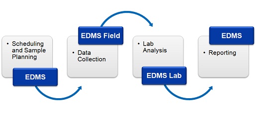
Get a Free copy of EDMS Field October 2016: Until the end of this year we are offering a free license of EDMS Field with every license of EDMS that you purchase. That is a savings of $695 US. The EDMS Field application is a separate program that can be run on tablets and laptops to collect environmental data and then send this data remotely to the EDMS application. The field data consists of sample and station information and is transmitted as Electronic Data Interchange (EDI) files to EDMS. EDMS Field is used in conjunction with EDMS to improve and standardize environmental data collection, management, and reporting in an efficient and cost-effective manner. This is accomplished by implementing a documented, auditable process for the collection, storage, and reporting of environmental field data. Throughout this process all stages of the sampling and analysis are tracked and notifications can be sent via email or SMS (text message). Notifications for non-compliance events For more information on EDMS Field, click here.
|
|
|
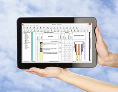
WinLoG RT Released August 2016: WinLoG RT can create boring and well logs and manage boring and well data. The program can be used on tablets, laptops and desktops that have the Windows operating system. The user interface has been specifically designed to make data collection easier on tablets and laptops. WinLoG RT can be used separately or as a field extension of the WinLoG/StrataExplorer application. When used separately it operates very similar to WinLoG version 4. All of the data is stored on the local device and the logs can be printed directly from the local device. WinLoG RT can be used completely independently of WinLoG and does not require any other software. When used in conjunction with the network version of WinLoG/StrataExplorer, WinLoG RT can act as a remote data collection device for boring and well data. The data collected in the field can be sent to the network as an Electronic Data Exchange (EDI) file. In addition, boring and well creation tasks can be automatically sent to personnel using WinLoG RT. For more information on WinLoG RT, click here.
|
|
Environmental Data Management System Released June 2016: The Environmental Data Management System (EDMS) is used to improve and standardize environmental data collection, management, and reporting in an efficient and cost-effective manner. This is accomplished by implementing a documented, auditable process for the collection, storage, and reporting of environmental field data. Throughout this process all stages of the sampling and analysis are tracked and notifications can be sent via email or SMS (text message). Notifications for non-compliance events and sample exceedences can be automatically sent by the system. This process can be divided into four stages:
Benefits Some of the many benefits provided by EDMS are:
Features The main features of the EDMS can be divided into several categories.
|
Products
Services
Resources
Other
© Copyright 2023: GAEA Technologies Ltd.
