Effortlessly Create Geologic Cross-Sections
Are you tired of struggling with complicated software?
Transform your geologic workflows with WinFence, the ultimate cross-section and fence diagram software. Say goodbye to the frustration of complicated tools and hello to effortless, intuitive solutions. Easily visualize subsurface geology and empower your projects through increased productivity. If you're ready to cast aside dense software, start your journey with WinFence today!
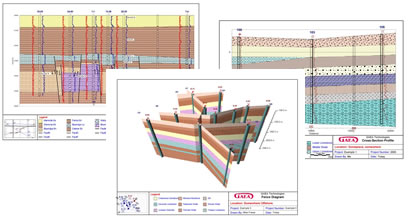
The WinFence module of GaeaSynergy can be used to quickly create detailed full color cross-sections. A wide variety of strata can be used to create cross-sections; such as layers, faults, lenses, intrusions, and alteration zones. This module shares the same database as the WinLoG module and can be used to access and plot the boring and well data.
There is the option to have the program automatically generate the cross-section using the borehole and well data. When determining how to connect the strata between boreholes, wells, and intersecting cross-sections the program looks at the similarities in the lithologies, thicknesses, and occurrence of the strata.
A unique snapping approach can be used to add layer boundaries. This approach allows the boundary of one strata to be fixed to the boundary of another strata. Making the input of strata boundaries quick and accurate.
After the cross-sections have been created, they can be displayed in 3D as fence diagrams.
Experience user-friendly software with no commitment.
Complete your purchase in just a few clicks.
Complete your work faster and with less hassle.
GAEA Technologies develops and distributes geoscience and engineering solutions worldwide. Our solutions have been used for over 30 years by companies and organizations around the world.
© 2026 - All Rights Reserved/span>